Utah road trip: Arches National Park part 1

Arches National Park in southern Utah in April, 2023.
(photo property of JoesWorldTour.com – all rights reserved)
Arches National Park in southern Utah in April, 2023.
(photo property of JoesWorldTour.com – all rights reserved)
There is a lot more to Arches National Park than just arches.

The park just north of Moab, Utah, has rugged trails, curvy roads and scenic views of red rocks and – if the weather behaves – really blue skies.

Arches: National Park Service

Utah road trip: Dead Horse Point State Park

Dead Horse Point State Park near Moab, Utah, in April, 2023. 
(photo property of JoesWorldTour.com – all rights reserved)
Dead Horse Point State Park near Moab, Utah, in April, 2023.
(photo property of JoesWorldTour.com – all rights reserved)
Dead Horse Point itself sits at 5,900 feet in elevation and looks down over a U-turn in the Colorado River about 2,000 feet below.

The park is west of Moab, Utah, and located is a short distance from the northern entrance to Canyonlands National Park.

Utah road trip: Canyonlands National Park – Island in the Sky

View from the Green River Overlook at Island in the Sky mesa in Canyonlands National Park near Moab, Utah.
(photo property of JoesWorldTour.com – all rights reserved)
View from the Green River Overlook at Island in the Sky mesa in Canyonlands National Park.
(photo property of JoesWorldTour.com – all rights reserved)
The Canyonlands National Park road across the Island in the Sky mesa includes pullouts with great views at Green River Overlook and Grand View Overlook.

There are plenty of trails and camping is available at the park.

You reach the Canyonlands Island in the Sky visitor center by taking Highway 313 southwest from Highway 191, which is the north-south highway to and from Moab, Utah.

National Park Service: Canyonlands


Utah road trip: Canyonlands National Park – The Needles district

The Needles District of Canyonlands National Park in Utah.
(photo property of JoesWorldTour.com – all rights reserved)
The Needles District of Canyonlands National Park in Utah.
(photo property of JoesWorldTour.com – all rights reserved)
There is more than one entrance to Canyonlands National Park in southern Utah.

The southeast part of Canyonlands is about an hour and a half drive heading south from Moab, Utah. That entrance takes you to the park district called The Needles.

According to Earth Trekkers, the park gets its name from clusters of sandstone spires.

EarthTrekkers.com

National Park Service – The Needles

The morning I got here, the sky ranged from cloudy when I first showed up to mostly sunny but still hazy. I never got any really blue-blue skies, and then it clouded up again. My best shots were in that stretch of about an hour when I got at least some sun and sort of blueish skies.

I apparently headed out just in time. Heading north I drove through a momentary now flurry and then some wind and rain. That cleared up in time for me to make an afternoon visit to the north side of the park.

Utah road trip: Newspaper Rock Archaeological Site

Newspaper Rock Archaeological Site near Canyonlands National Park. 
(photo property of JoesWorldTour.com – all rights reserved)
Newspaper Rock Archaeological Site near Canyonlands National Park.
(photo property of JoesWorldTour.com – all rights reserved)
As you drive toward the southeastern entrance to Canyonlands National Park in southern Utah, you pass a very small pulloff for Newspaper Rock.

It’s worth the stop.

The carvings in the rock are estimated to be up to 2,000 years old.

Newspaper Rock: Bureau of Land Management

Newspaper Rock Archaeological Site near Canyonlands National Park. 
(photo property of JoesWorldTour.com – all rights reserved)
Newspaper Rock Archaeological Site near Canyonlands National Park.
(photo property of JoesWorldTour.com – all rights reserved)

Utah road trip: Colorado River near Moab

The Colorado River flows under Utah's Highway 191 between Moab and the entrance to Arches National Park.
(photo property of JoesWorldTour.com – all rights reserved)
The Colorado River flows under Utah’s Highway 191 between Moab and the entrance to Arches National Park.
(photo property of JoesWorldTour.com – all rights reserved)


Utah’s Highway 191 crosses over the Colorado River within walking distance of the Moab city limits and about three miles from the entrance to Arches National Park.

There is a nice place to park next to the river called Lions Park and Transit Hub. The stop also has restrooms and access to a paved bicycle lane.

Utah road trip: Green River

The Green River running through the town of Green River, which is northwest of Moab.
(photo property of JoesWorldTour.com – all rights reserved)
The Green River running through the town of Green River, which is northwest of Moab.
(photo property of JoesWorldTour.com – all rights reserved)
The town of Green River in southern Utah takes its name from the river that flows through it.

Including some hotels, restaurants, a couple of truck stops and a few brightly colored fruit stands, the town of Green River sits near the intersection of Highway 6, heading northwest to southeast, and Interstate 70, which runs west to east through northern Colorado to Denver and all the way to the East Coast.

The river is fed by snow melt and has a lot of water flowing through it in late April. Green River joins up with the Colorado River south of here in Canyonlands National Park.

Utah road trip: Driving from Salt Lake City to Moab

Driving from Salt Lake City to Moab in southern Utah.
(photo property of JoesWorldTour.com – all rights reserved)
Snow in the mountains along Highway 6. Driving from Salt Lake City to Moab in southern Utah.
(photo property of JoesWorldTour.com – all rights reserved)
I left the interstates behind me for most of the drive from Salt Lake City to southern Utah.

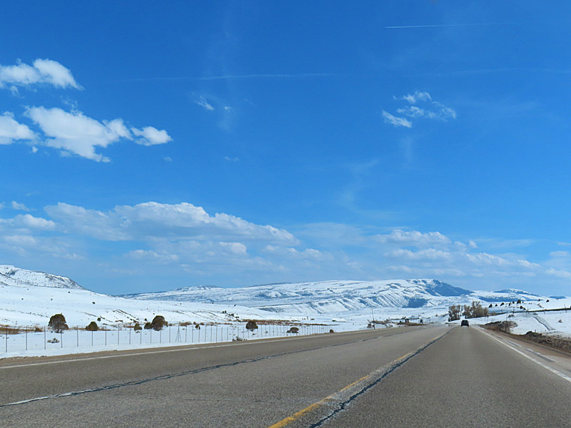
The drive through the mountains on Highway 6 takes you to elevations as high as 7,477 feet. I see a sign along the way that marks Soldiers Summit at 7,477 feet. There is snow around the road at the higher elevations, but the road itself is clear and dry.

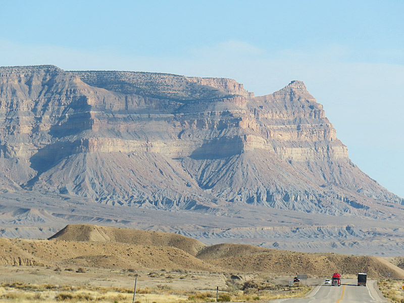
I’m back down to around 4,000 feet when I hit Interstate 70 near Green River, Utah, and head east about 20 miles to pick up Highway 191 south toward Moab. I passed the entrances to the northern section of Canyonlands National Park and about 10 miles later Arches National Park shortly before I reached the Moab city limits.

Driving from Salt Lake City to Moab in southern Utah.
(photo property of JoesWorldTour.com – all rights reserved)
Back down to lower elevations. Driving from Salt Lake City to Moab in southern Utah.
(photo property of JoesWorldTour.com – all rights reserved)
Driving from Salt Lake City to Moab in southern Utah.
(photo property of JoesWorldTour.com – all rights reserved)
Almost there. Driving from Salt Lake City to Moab in southern Utah.
(photo property of JoesWorldTour.com – all rights reserved)

Utah road trip: Flying over the Rocky Mountains from Denver to Salt Lake City

Wheels up in Denver as we take off for Salt Lake City.
(photo property of JoesWorldTour.com – all rights reserved)
Wheels up in Denver as we take off for Salt Lake City.
(photo property of JoesWorldTour.com – all rights reserved)
The Denver airport is a major hub and it’s a relatively short flight from there to Salt Lake City, the second step of my road trip.

I actually got a better view of downtown Denver flying out of the airport there and heading northwest than I did on the flight into Denver coming from the south.

If you live in certain parts of the south and especially if you live near the coast, you might not get to see a lot of snow or mountains. Flying over the Rocky Mountains gives you a close-up view of both.

Flying over the Rocky Mountains on the way from Denver to Salt Lake City.
(photo property of JoesWorldTour.com – all rights reserved)
Flying over the Rocky Mountains on the way from Denver to Salt Lake City.
(photo property of JoesWorldTour.com – all rights reserved)

Utah road trip: First step is flying to Denver

Approaching Denver's airport, you can see how far it is away from the city. (photo property of JoesWorldTour.com – all rights reserved)
Approaching Denver’s airport, you can see how far it is away from the city.
(photo property of JoesWorldTour.com – all rights reserved)
There’s no quick way to get from my home town to southern Utah.

To start with, I didn’t see any non-stop flights available from my airport to Utah.

My trip got going with a morning flight into Denver, where I would change planes.

The relatively new Denver airport is actually a good distance east and a little north of town. Way off in the distance you can see the Rocky Mountains.

The Rocky Mountains are on the horizon west of the city as you fly into the Denver airport. (photo property of JoesWorldTour.com – all rights reserved)
The Rocky Mountains are on the horizon west of the city as you fly into the Denver airport.
(photo property of JoesWorldTour.com – all rights reserved)
The Denver airport is designed to look like mountain peaks as you land. (photo property of JoesWorldTour.com – all rights reserved)
The Denver airport is designed to look like mountain peaks as you land.
(photo property of JoesWorldTour.com – all rights reserved)